Here is a video by Yannis Sakellarakis, an archaeologist, of a new Minoan site in Crete.
I hope that you enjoy it.
Here is a video by Yannis Sakellarakis, an archaeologist, of a new Minoan site in Crete.
I hope that you enjoy it.
By Owen Jarus
A team of archaeologists have discovered a fortification system at the Minoan town of Gournia, a discovery which rebukes the popular myth that the Minoans were a peaceful society with no need for defensive structures.

The team’s efforts were led by Professor Vance Watrous and Matt Buell of the University at Buffalo. Located on the north coast, Gournia was in use during the neo-palatial period (ca. 1700-1450 BC), when Minoan civilization was at its height. The town sits atop a low ridge with four promontories on its coastline. Two of these promontories end in high vertical cliffs that give the town a defensive advantage, and it is here that the fortification system was discovered.
The team weren’t able to excavate the area, and so relied on photography, drawing and surveying to identify the fortifications. The eastern-most promontory had a heavy wall that was about 27 meters long. Beside it the team found a semi-circular platform of stone, almost nine meters in diameter, which they believe is the remains of a tower or bastion. The other fortified promontory had a two meter thick wall, running east-west, “as if to close off access from the sea,” said Buell.
The other two promontories slope gently down to the shore, and would have provided easy access to the town. “It was on these two promontories”, said Professor Watrous, “that the Minoans built structures.”
The town consists of around 60 tightly-packed houses, a ship shed, and a small palace in the centre, and archaeologists have discovered evidence of wine making, bronze-working and stone-working at the site. “Gournia gives you, the visitor, a real feeling of what an Aegean town was actually like. Walking up the streets, past the houses, you feel like you’ve been transported into the past,” said Buell.
In addition to the beach fortifications, it also appears that the Minoans built a second line of defence further inland. Heading back from the beach, there were two walls, together running about 180 meters east to west. Backed by a tower, or bastion, the walls would have posed a formidable challenge to any invader trying to march into the town.
Defenders manning this system of fortification would have rained projectiles down on attackers, by using bows and slings. The walls had stone foundations and were made of mud brick, making them sturdy enough to stand on.
It’s an open question as to whether the people guarding the fortifications were part of a militia or something more organized. There was “definitely a body of men who would have had that duty but we don’t know exactly what they were like,” said Professor Watrous.
Tombs uncovered by Hawes and other excavators have shown people buried with swords. Watrous said that there was one particular tomb that produced an entire collection of daggers, swords and other items.
However, Gournia’s fortifications did not prevent the town’s demise. The town fell around 1450 BC, along with other Minoan settlements. A new group called the Mycenaean appeared on Crete at this time, taking over the island.
Watrous said that Mycenaeans probably avoided attacking the town by sea. “Many other settlements were destroyed at the same time. My guess is that they just came along the land; they didn’t have to come up from the sea”.
He cannot say for sure if the town defences were ever actually put to their intended use. Any evidence of a battle near these fortifications, such as weapons or bodies, would be underground, and excavation would have to be carried out to see if they exist.
One thing that excavators can say is that the people of Gournia had something worth fighting for. Many of the goods they made – such as the wine and the bronze implements – were for export, suggesting that the people had some level of wealth.
Archaeologists from the University of Haifa, who are conducting excavations in the city of Tel Kabri, found Minoan style frescoes, similar to those discovered in the Aegean islands of Crete and Santorini dating back to the 17th century BC. These are the first such frescoes to be discovered in Israel.
According to scientists’ estimations, the wall paintings in the Canaanite palace in Kabri are a conscious decision by the city’s rulers who wanted to adopt the Mediterrenean culture rather than the Syrian and Mesopotamian art styles adopted by other cities in Canaan.
In an earlier excavation, another fresco similar to those of Santorini was unearthed, but the new discoveries established the fact that the first fresco was not a coincidence but that the ancient city of Tel Kabri not only had developed commercial relations with the Aegean and Minoan world but wanted to come close to and be associated culturally with these civilisations.
The team, writing in the October issue of Geology, said the new evidence suggested that giant tsunamis from the catastrophic eruption hit “coastal sites across the Eastern Mediterranean littoral.” Tsunamis are giant waves that can crash into shore, rearrange the seabed, inundate vast areas of land and carry terrestrial material out to sea.
The region at the time was home to rising civilizations in Crete, Cyprus, Egypt, Phoenicia and Turkey.

For decades, scholars have suggested that the giant eruption, just 70 miles from Crete, might have brought about the mysterious collapse of Minoan civilization at the peak of its glory. The remnants of Thera’s eruption today make up a circular archipelago of volcanic Greek isles known as Santorini.
Thera is thought to have erupted between 1630 and 1550 B.C., or the Late Bronze Age, a time when many human cultures made tools and weapons of bronze. Scholars say the tsunamis and dense clouds of volcanic ash from the eruption had cultural repercussions that rippled across the Eastern Mediterranean for decades, even centuries. The fall of Minoan civilization is usually dated to around 1450 B.C. Geologists judge the eruption as far more violent than the 1883 eruption of the volcanic island of Krakatoa in Indonesia, which killed more than 36,000.
The five tsunami researchers came from Haifa University, in Israel; Hunter College, in New York City; McMaster University, in Canada; and the University of Hawaii.
The team did its excavations off Caesarea, Israel, a coastal town dating from Roman and Byzantine days. The coastal region was only sparsely settled at the time of the Thera eruption, with no identifiable city.
The team sank a half-dozen tubes into the offshore seabed and pulled up sediment cores for analysis. It looked for standard signs of tsunami upheaval, including pumice (the volcanic rock that solidifies from frothy lava), distinctive patterns of microfossils, cultural materials from human dwellings and well-rounded beach pebbles that seldom appear in deeper waters.
Writing in Geology, a journal published by the Geological Society of America, the team reported finding evidence of three tsunamis — two historically documented ones dating to A.D. 115 and 551, and one from the time of the Thera eruption.
The Thera tsunamis, the team wrote, left a signature layer in the seabed of well-rounded pebbles, distinctive patterns of mollusks and characteristic inclusions in rocky fragments all oriented in the same direction.
The disturbed layer, up to 16 inches wide, came from a few feet below the seabed in waters up to 65 feet deep.
“These findings,” the team wrote, “constitute the most comprehensive evidence to date that the tsunami event precipitated by the eruption of Santorini reached the maximum extent of the Eastern Mediterranean.”
The team added that, if the giant waves were big enough to reach Israel, “then presumably other Late Bronze Age coastal sites across the Eastern Mediterranean littoral will likely have been affected as well.”
By WILLIAM J. BROAD
New York Times
November 3, 2009
In the whole of the island of Crete, one area that is still magical today as well as being vitally important to the history of Crete, is the Mesara Plain. The Mesara is in southern central Crete in the south of the Nomos of Iraklion. It is the biggest plain in Crete and very important for the extensive agriculture that is produced there both now and around five thousand years ago.
The name ‘Mesara’ comes from the Greek for ‘between mountains.’ Mesos – between, oros – mountains, which becomes Mesaoria or the modern word, Mesara. In the north are the southern foothills of the Psiloritis or Ida mountain range and in the south are the Asterousian mountains between the Mesara and the Libyan Sea. The coastline of the Mesara faces west almost from Agia Galini in the north to Matala in the south. Between the two is one of the most perfect and extensive beaches in Crete, mostly with hardly a soul to be seen.
Two rivers flow through the Mesara and both have their source near to the village of Asimi. From there they flow in opposite directions. Geropotamos, known in ancient times as Lethaios, flows westwards to the sea and out into the Gulf of Mesara. Anapodaris, ancient name Katarhaktes, flows into the bay of Derma, east of the village of Tsoutsouros.
Here in the Mesara in ancient times, civilisation grew from Neolithic (5th Century BC) to the modern day. During the Minoan Prepalatial period growth was amazing (4th & 3rd centuries BC) where huge leaps forward were taken in architecture, pottery, the incredible circular tholos tombs, Agios Onoufrios and Kamares ware, countless figurines, seals and jewelry were produced.
In the first Palace period we see the palace at Festos being built (1900 – 1700 BC). The second Palace period was centered around the later palace at Festos, the palatial buildings at Agia Triada and at the port of Kommos just north of Matala near Pitsidia (1700 – 1300 BC).
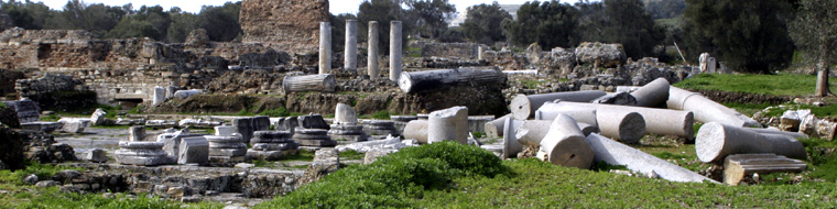
Later the came Gortyn, the magnificent city that dominated the Mesara for sixteen centuries, from 800BC to 800AD. Gortyn is situated just west of Agioi Deka and covered a diameter of ten kilometres. It is said that in its greatest years over 80,000 people lived in Gortyn and in Roman times it became not only the capital of Crete but the Capital of Cyrene as well (North Africa).
There is still a plane tree in the ruins of Gortyn that keeps its leaves all year. Under that tree Zeus made love to Europa and the children that they produced were Minos, the king at Knossos and his brother Rhadamantys, King of Festos.
